Satubumi
Production Backend API, Rapid-FS Scoring Engine & Digital MRV Platform for Nature-Based Solutions.
Satubumi is an enterprise-grade backend ecosystem engineered to power digital ecological restoration, carbon project feasibility, and nature-based solutions (NbS). Built on a modern FastAPI and PostgreSQL stack, it bridges complex remote-sensing telemetry with clean, high-concurrency APIs. The system runs two mission-critical pillars: the Carbon Assessment Engine (featuring the 7-stage ICPFS feasibility pipeline) and Satubumi Monitor—a full-fledged Digital Measurement, Reporting, and Verification (MRV) platform tracking living ecosystems from satellite orbits down to individual tree survival on the ground.
Rapid-FS Carbon Feasibility Engine (7-Stage ICPFS)
Engineered an automated 5-pillar scoring algorithm (Carbon, Legality, Biodiversity, Social, and Economy) that auto-unzips ESRI Shapefile archives, computes hectares via WGS84 coordinate reprojection, and projects carbon credit yield with zero manual data entry.
Digital MRV & 7-Layer GIS Streaming
Delivers optimized GeoJSON streaming across 7 spatial layers (project boundaries, permanent plots, tree locations, patrol routes, and biodiversity sightings), integrated with Google Earth Engine (Sentinel-2 & Hansen GFC) for live NDVI and forest cover dynamics.
Real-Time Ecological Alert Engine
Constructed a 5-rule heuristic engine that continuously evaluates field logs to detect critical survival drops (<70% and <50%) and overdue monitoring (>30 days), complete with a deduplication pipeline to prevent alert fatigue.
Stateless JWT Security & Dynamic Masking
Architected stateless JWT authentication with bcrypt password hashing and 4-tier Role-Based Access Control (Super Admin, Admin, Client, Field Officer), featuring automated data-masking and preview-blur workflows for unverified tenant accounts.
Automated MRV Reporting & Currency Gateway
Automated publication of official carbon feasibility and MRV executive dossiers using ReportLab, backed by a real-time USD ⇄ IDR currency conversion service with in-memory TTL caching and dynamic bilingual content APIs.
- Index
- 01
- Role
- Backend & Geospatial Engineer
- Year
- 2026
- Architecture
- Layered Service Pattern (Router–Service–Model)
- Core Stack
- Python 3.11+ · FastAPI · Starlette · Pydantic v2
- Database
- PostgreSQL · SQLAlchemy 2.0 · Alembic
- Geospatial & Remote
- Shapely · PyProj · PyShp · Google Earth Engine
- Security & Auth
- PyJWT · Passlib (Bcrypt) · RBAC · SlowAPI
- Reporting & Docs
- ReportLab · xhtml2pdf · PyPDF
- DevOps & Caching
- Docker · Docker Compose · Redis & In-Memory TTL
Technologies & Tools
Engineering Artifacts & System Visuals
High-resolution architecture blueprints, geospatial pipeline diagrams, and satellite MRV telemetry feeds.

Rapid-FS 7-Stage Carbon Feasibility Pipeline
Production architecture demonstrating automated ESRI Shapefile ingestion, PyProj WGS84 coordinate reprojection, 5-pillar carbon scoring, and automated PDF dossier publishing.
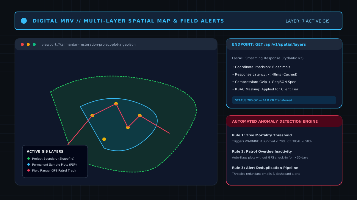
Digital MRV Multi-Layer GIS Map & Heuristic Alert Engine
FastAPI streaming endpoints delivering 7 GeoJSON spatial layers (project boundaries, sample plots, ranger patrol GPS routes) alongside automated tree survival anomaly triggers.